SloveniaHolidays.com > Attività > Attivita' invernali > Sciare > Golte - Ljubno - Žekovec
Golte - Ljubno - Žekovec

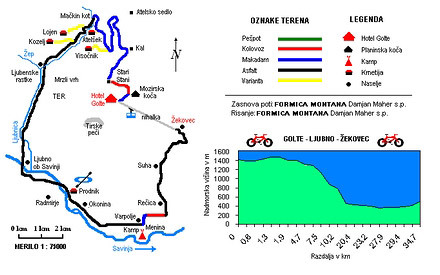
punto di partenza: : Hotel Golte - zgornja postaja nihalke
- lunghezza:
34.0 km - tempo:
03:00:00 - difficolta:
media - fondo:
asfalto, brecciato, sentiero
Descrizione della strada
The route begins at the Golte Hotel, upper station of the lift.
0.5 km Wooden gate, close it behind you! M S2 P3
0.6 km Turn left, metal gate, close it behind you!K V3-V4 P3
1.0 Turn left (road toward Boskovec on the right).K V3-V4 P2
1.3 Turn right atop the steep slope.K V2 P3
1.7 Wooden gate, close it behind you! Lahovnica. K S2 P3
1.9 STOP, electrified fence. K V2 P4
2.5 Stari Stani. Turn left. M S2P5
4.7 Go straight ahead, road toward Kal and Smrekovec on the right. M S2 P2
5.0 Go straight ahead, road toward Atelsko sedlo, Smrekovec and Črna na Koroškem on the right. M S2 P2
7.5 Go straight ahead, road toward Visočnik tourist farm on the left. M S2P4
8.0 Visočnik tourist farm.M S2 P5
8.7 Mačkin kot, turn left, road toward Smrekovec on the right.A S2 P2
10.2 Go straight ahead, road toward the Atelšek tourist farm on the left.A S2P4
10.7 Atelšek tourist farm.M S2 P5
18.7 Ljubno ob Savinji.A S2 P4
20.4 Center, turn left.A S2P4
20.6 Turn left onto the main road (signpost for Mozirje).A S1 P4
23.2 Go straight ahead, road toward the Prodnik sports center on the right. A S1 P4
23.2 Prodnik sports center (kayak, canoe, rafting).A S1 P4
27.6 Varpolje, 20 m behind the bus station, turn left onto the macadam M S1 P4
27.9 Turn right toward the hop field.K S1-V1 P4
28.9 Stream by the Savinja, turn left.A V1 P4
29.4 Roundabout, signpost for Golte, Bider tourist farm.A V1-V3 P4
33.8 Turn left, signpost for Golte Golte.A V3 P4
34.7 Žekovec, lower station of the lift
Difficulty – descent: from S1 to S5
- S1: easy, not at all exposed descent
- S5: very difficult, exposed descent
Difficulty – ascent: from V1 to V5
- V1: easy, undemanding ascent
- V5: difficult, very demanding ascent
P - panorama: from P1 to P5
- P1: no views or sights
- P5: fun, interesting views of the area
Terrain markings:
- P: walkway
- K: gravel road
- M: macadam
- A: asphalt
You'll have to get off your bike a few times due to the wooden gates and electrified fences.
AVVISO:
Per la descrizione delle strade ciclabili, puntualita' e precisione dei dati l'autore di questa pagina non si assume nessuna responsabilita'. Le strade ciclabili le abbiamo presentate nella maniera migliore possibile. La valutazione per la realizzazione del giro e' soggettiva per ognuno che lo realizza o legge queste pagine. Il decreto della corsa nell'ambiente naturale (UR. l. RS 16,28/95)


